The days since my research trip to Dublin, Ireland have quickly slipped away, but in addition to the travel log that I already blogged about, it's important to expand upon the most exceptional discovery I made. What better time to reflect on that find than on St. Patrick's Day? For a full look at how the discovery came about, click here for Day 3 of my Dublin adventures last year in 2023.
Kira D. Foltz at the National Library of Ireland, October 2023
It was my very first day of doing research in a foreign country. I was in the Manuscripts Reading Room of the National Library of Ireland, and I was digging through the estate papers of the Cole-Bowen family in hopes of finding any mention of my Keeffe/O'Keeffe ancestors of County Cork. But more importantly, I was hoping to find a map of the local area in which they lived during the famine years.
National Library of Ireland Manuscripts Room, October 2023
The smallest unit of land is called a "townland" in Ireland, but those names were only standardized around the 1830s. The official townland in which the Keeffes were living in County Cork was called Farahy (with various spellings), but the locals distinguished their residence even more specifically than that as being "of Lismonihis."
The name Lismonihis (which also carried many various spellings) appeared in their local church's records. My 4th great grandfather, Terence Keeffe, was said to be of "Lismonihis" when he married my 4th great grandmother, Anne Mead of "Meadstown", in Kildorrery Church.
Kildorrery Church, Keeffe-Mead marriage record, 25 Jan 1826, Kildorrery, County Cork, Ireland; database with images, Ancestry (https://www.ancestry.com : accessed 16 Mar 2024).
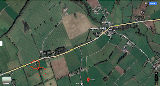
In nearby graveyards around Farahy, there are also tombstones engraved with the placename Lismonihis, as well. However, despite there being some historical records of this place's existence, not a single modern map can give you its location. And to top it off? None of the historical maps online can either!
Ordnance Survey of Ireland, undated map of Farahy, County Cork, Ireland.
Because Lismonihis was not selected as an official townland, it didn't make it onto the maps of record. Instead, it remained as more of a sub-townland, farm, or neighborhood. Only true locals would be able to describe where it was. I was determined to find a more ancient map (pre-1830s) or more detailed local map that would outline its boundaries during the time my family lived on the land.
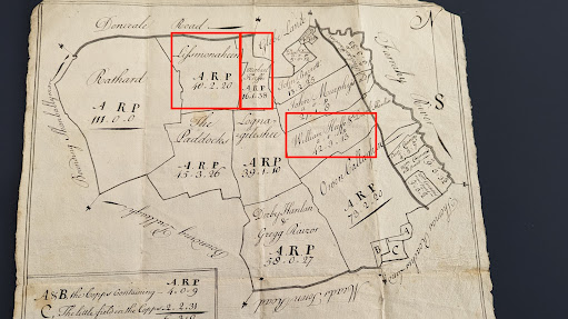
The estate collection did not disappoint me! I miraculously stumbled upon a map of the area from 1754!
John Holland, "A Mapp or Survey of part of the Lands of Farryhy," 1754, County Cork, Ireland;
Courtesy of the National Library of Ireland.
I certainly didn't even need Lismonihis to be spelled the way I had been accustomed to seeing it. I flipped to this map in the manuscript file and was able to spot it instantly: Lissmonaheen! I was overjoyed! When I first blogged about this find a few months ago, I was not able to include this detailed photograph in my post, because I had not yet requested permission from the NLI to publish the image. However, now that I've obtained that right, here it is in all its glory and definition.
"Lissmonaheen," as it was referred to in this survey, sat to the south of Donerale Road (now the Mallow-Dublin Rd. or Route N73) between the land of Michael Keeffe and Rathard. At its southern border were The Paddocks and Lognagileshee. Every plot pictured above now sits within the townland of Farahy in the northern parts of the County of Cork. If the map had also drawn the lands on the northside of Donerale Road, it would have included what became known as Bowen's Court (the Glebe Land was also a part of the Bowen estate).
At this point in time, it referred to each plot as a farm. The A.R.P. initials and corresponding numbers were meant to signal how many acres, roods, and perches the land made up. In the case of "Lissmonaheen," it totaled 40 acres, 2 roods, and 20 perches. The legend stated that 4 acres and 3 roods of that belonged to Denis Ninan. The remaining acres were in possession of Lewellin Nash, Esq. (who had commissioned the survey be drawn up). It was done so at a scale of 40 perches plantation measure to an inch. That would equal a quarter acre per inch, as 160 perches made up 1 acre.
By the time of Griffith's Valuation (a tax record), circa 1848 in Farahy, Terence O'Keeffe was living on just over 26 acres in Farahy, so nearly 3/4 of what was marked as "Lissmonaheen." Of course, that was about 100 years after the above map was drawn, so the borders may have shifted between the farms slightly by then. But in early 2023, a volunteer went door to door for me around the area and confirmed the same fields had recently been known as part of Lismonihis. Sadly, the residents have all ceased using the name in their mailing addresses, and it's likely within the next 100 years, it will be lost to time completely.
Google Maps, aerial satellite view of Farahy, ca. 2023, County Cork, Ireland.
It's important to point out there are 2 men on this 1754 map carrying my ancestor's surname, Keeffe. As Terence was not born for another 50 years after this map's creation, it begs the question as to how these men, Michael and William Keeffe were related to him.
John Holland, "A Mapp or Survey of part of the Lands of Farryhy," 1754, County Cork, Ireland;
Courtesy of the National Library of Ireland.
It's quite likely one may have been Terence's grandfather, perhaps the one living on the land adjoining "Lissmonaheen," Michael. Though maybe it was William, considering the map indicates he actually owned 8 of his farm's acres outright (which was highly unusual for a Catholic at that time and may suggest a higher social standing or elder status). Unfortunately, very few written records still exist from this time period that could be used to draw final conclusions on relationships between lower or middle class Catholic farmers. The fact these Keeffe men were even named on this private map is quite something! I'm lucky to have found this.
I now know from other research on this Dublin trip that Terence's father was Arthur Keeffe (my 5th great grandfather), and from this map, I now have a hypothesis that Terence's grandfather (my 6th great grandfather) was Michael Keeffe (based solely on proximity). That will more than likely be the end to that paper trail, but it's quite exciting as it is and wouldn't be possible without this map!
There are many hidden clues on this map that I'd love to study further (such as the Keeffe relationship with the Hanlan family or Nash's landholdings in general). It's fantastic that it gives names (and people living on them) for all of these local farms. Lismonihis was not the only placename to have been dropped from modern maps. Most all of these names are no longer used, but they would absolutely assist family historians in tracking down exactly where their ancestors lived, especially if they are in similar shoes to mine where the church record gives their residence as the name of the farm, and yet, that farm name is nowhere to be found on a map!
I hope if anyone is hunting for these lesser-known localities, they stumble upon this page and make the same incredible discovery that I did. Shanballymore, Poulleagh, and Meads Town (Meadstown) were also listed on the borders. The other names on the map included: Daniel Dinny, Maurice Fitzgerald, John Barrott, John Murphy, Daniel Hanlan, Owen Callaghan, Derby Hanlan (likely aka Jeremiah Hanlan), Gregg Raizor, William Conner, Cornelius Conner, and Phelix Hanlan (likely aka Felix Hanlan). Finally, John Holland was the map's surveyor and cartographer.
Several of the surnames on the 1754 map remained in the area by Griffith's Valuation 100 years later, some with slight spelling variations. It's probable these men were ancestors of Thomas Fitzgerald, Ellen Fitzgerald, John Fitzgerald, Patrick Connor, John Connor, Cornelius Hanlon, John Hanlon, and/or Patrick Barrett, all living in Farahy in 1848.
If I had known all of these farm names and residents heading into my research trip, it's likely I could have discovered even more. But any remaining questions will now have to be answered on future excursions!


Comments
Post a Comment